Settings
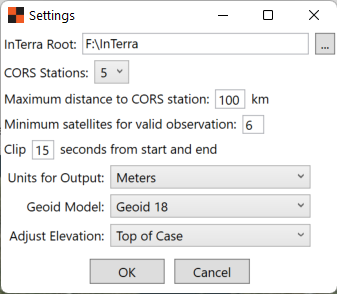
The Settings dialog allows the user to:
- Select the InTerra Root folder, or path where Projects will be saved.
- Select the default number of CORS Stations to retrieve. If set to 0, then the user will need to supply a base station at the appropriate time.
- Select the Maximum distance from the Project site for CORS Stations. It is advisable to use the closest CORS Stations available, although availability may affect data access.
- Select the Minimum number of satellites for valid observations. A recommended value range of 6 to 10 satellites.
- Select the number of seconds to clip from the start and end of observations. This is useful if there was time spent standing over the units when placing or retrieving. A recommended value is 15 seconds.
- Select the units for processing and Output. Units will be Meters, US Survey Foot, or International Foot.
- Select the Geoid Model to use when processing output.
- Select where to Adjust the Elevation calculation. Top of case will adjust the elevation to the SmarTarget top. Bottom of case will adjust the elevation to the SmarTarget bottom. And Antenna Line is adjusted to the Orange/Black interface which serves as the Antenna Reference Plane.