
FHWA Drone Compliance Is Here — And InTerra Is Ready
The regulatory environment for drones used on federally funded transportation projects has entered a new phase. In December 2025, the Federal Highway Administration (FHWA) formally implemented the American Security Drone Act of 2023 (ASDA) along with OMB Memorandum M-26-02, setting clear requirements that directly affect State DOTs, consultants, and contractors nationwide per the FHWA Drone Policy Email Notification.
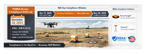
Effective December 22, 2025, FHWA staff, contractors, and recipients of federal funds are prohibited from purchasing, operating, or funding covered unmanned aircraft systems (UAS) manufactured by prohibited foreign entities. These restrictions apply not only to aircraft, but to all associated components, including ground controllers, communication links, cameras, and gimbals. FHWA has also directed immediate cessation of covered UAS operations and requires agencies to verify inventories to prevent unallowable costs.
Beyond the immediate operational impacts, FHWA has established a clear compliance timeline. Agencies have 180 days, through May 20, 2026, to finalize policy and procedural alignment, including UAS inventory tracking, confirmation of procurement practices, and full alignment with ASDA and NDAA standards. As of this writing, December 22, 2025, the Missouri DOT has already issued a public statement outlining its approach, and other State DOTs are expected to follow with similar guidance.
Accuracy Still Matters - Compliance Is Now the Baseline
For drone-based mapping, surveying, and inspection workflows tied to federal funding, compliance is now a baseline requirement. However, regulatory compliance alone does not produce usable engineering data. Accuracy, repeatability, and defensibility remain non-negotiable because transportation decisions, quantities, and designs depend on them. In drone mapping, that accuracy is achieved through the proper use of survey-grade Ground Control Points (GCPs), which anchor photogrammetric models to known, verifiable coordinates and dramatically reduce error across large or complex sites.
Well-designed GCP workflows improve horizontal and vertical accuracy, enable consistent results across repeat flights, and provide a defensible reference when data is reviewed, audited, or challenged. For DOT and federally funded projects, this matters because deliverables must not only meet technical tolerances but also stand up to documentation, QA/QC, and long-term record requirements. In today’s environment, professional results are only defensible when high-accuracy GCP-based workflows are delivered using systems that also meet FHWA, ASDA, and NDAA standards, with clear documentation to support both performance and compliance.
InTerra: Accurate. Repeatable. Defensible.
This is where InTerra stands apart.
InTerra SmarTarget®, Datum™, and Locator™ are American-made, NDAA-compliant solutions purpose-built for professional surveying and transportation workflows:
- SmarTarget delivers survey-grade ground control with proven accuracy and repeatability.
- Datum provides a local GNSS base station when CORS coverage is unavailable, ensuring consistent corrections and defensible results.
- Locator is a desktop PPK processing engine that visually confirms target capture and documents compliance-critical workflows.
Together, they form a tightly integrated ecosystem designed not just to meet regulatory requirements but to support confident decision-making, withstand audit scrutiny, and produce repeatable, defensible outcomes.
As FHWA guidance continues to roll out and State DOTs formalize enforcement, agencies and consultants will be expected to justify not only the quality of their data, but the systems and processes used to generate it. InTerra customers can move forward with confidence—knowing their workflows are accurate, repeatable, defensible, and compliant.
The compliance clock is already running. InTerra is ready.
Built for Compliance. Proven in Practice.
Navigating new FHWA requirements doesn’t have to be complex with InTerra’s American-made, NDAA-compliant solutions. Our team is ready to help you transition to compliant, defensible workflows without sacrificing accuracy. Contact us or click here to schedule a call with our team.