
As drone adoption accelerates across construction, infrastructure, utilities, and public safety, the ability to produce repeatable, accurate, and defensible geospatial data is becoming the defining factor in professional drone mapping.
The global drone industry is entering a period of rapid expansion as organizations increasingly rely on aerial data to support engineering, construction, infrastructure management, agriculture, and public safety operations. Advances in sensors, autonomous flight systems, and geospatial processing tools have transformed drones from niche photography platforms into powerful tools for industrial data collection. As adoption grows, the demand for high-accuracy geospatial data has become increasingly important, particularly in industries where precise measurements directly influence design decisions, safety, and project outcomes.
Market forecasts reflect this accelerating adoption. Industry research estimates the global drone market will grow from approximately $73 billion in 2024 to more than $163 billion by 2030, representing sustained double-digit growth across commercial and industrial sectors. Within this expansion, mapping and surveying remain the most widely used commercial drone applications, accounting for roughly 35% of drone operations worldwide. As infrastructure development and large-scale construction projects increase, the ability to collect reliable spatial data quickly and cost-effectively is becoming a key driver of drone adoption.
However, as drones become more widely used for surveying and mapping, the industry is increasingly focused on measurement integrity. Capturing imagery is only the first step; ensuring that the resulting coordinates are accurate, repeatable, and defensible is essential for engineering, infrastructure, and regulatory applications. Reliable drone mapping workflows require a clear connection between aerial observations, ground measurements, and coordinate reference systems so that the resulting geospatial data can be trusted and reused across projects and organizations.
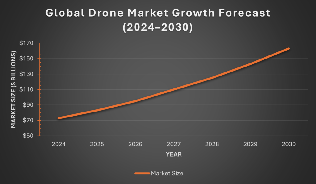
Source: Grand View Research
How InTerra Fits
InTerra addresses this challenge by providing a measurement framework designed specifically for high-accuracy drone mapping. The InTerra system combines three components: SmarTargets®, which act as witness measurements during drone flights; the Datum™ Local Base Station, which provides a nearby GNSS reference; and Locator™ software, which performs transparent post-processing of the collected observations. Together, these components establish a traceable link between field measurements and coordinate systems, enabling drone mapping workflows that produce repeatable, accurate, and defensible geospatial results.
By integrating witness measurements, local reference data, and standards-based processing, the InTerra system helps surveyors, engineers, and infrastructure professionals generate high-quality spatial data with greater confidence. As drone mapping adoption continues to expand across industries, measurement frameworks like this will play an increasingly important role in ensuring that drone-derived data meets the accuracy and reliability requirements of professional surveying and engineering applications.