
The Real ROI of Drone Mapping Starts Before the Drone Takes Off
Getting the data right the first time is what separates profitable workflows from expensive ones.
What Is the Real ROI of Drone Mapping? A Story About Time, Accuracy, and Getting the Data Right the First Time
It usually does not start with a spreadsheet. It starts in the field.
A crew is on site early, setting targets and running survey equipment with a quiet pressure to get everything right before the drone leaves the ground. Everyone involved understands the same risk. If the control is wrong, incomplete, or rushed, the entire job can unravel later.
The flight itself goes quickly, and the drone performs as expected. Data is captured, the team packs up, and they head back. Then the real question begins to take shape. Was that enough?
The Moment Where ROI Gets Decided
Back in the office, processing starts. Someone checks alignment, someone else looks at residuals, and there is a pause followed by a second look and sometimes a third. Sometimes everything lines up. Sometimes it does not.
When it does not, the cost is not theoretical. Time is lost reprocessing, crews may need to return to the site, schedules slip, and confidence drops. At that point, the conversation shifts. It is no longer about how fast the drone flew. It is about whether the data can be trusted. That is where ROI is actually decided.
Getting It Right the First Time
Accuracy is not just a technical requirement. It is a business driver. When data is right the first time, projects move forward without delay, teams do not repeat work, clients have confidence in deliverables, and schedules stay intact.
When data is not right, every downstream step absorbs the impact. The difference between those outcomes is where real value is created or lost.
This becomes even more apparent in real-time project environments where data feeds directly into decision-making. If the data is wrong, the decisions are wrong. If the data is late, the decisions are delayed. This is explored further in Using Drone Surveys with GCPs for Real-Time Monitoring of Construction Progress with AI where accuracy and timeliness directly affect outcomes in the field.
See Your ROI in Minutes
If you want to understand what this means for your operation, use the ROI calculator with your own inputs. It will show the payback period, monthly value created, year-one impact, and time saved per project.
👉 Access the ROI Calculator and Run Your Numbers
Why Workflows Matter More Than Equipment
Many firms invest in better drones, expecting immediate returns. After a few projects, they notice the same pattern. The drone is faster, but the project is not.
That is because the workflow still includes manual ground control placement, time-intensive survey steps, coordination between field and office, and validation processes that depend on perfect inputs. The drone improved one step while the rest remained unchanged. ROI does not come from a faster step. It comes from a better system.
The Real Constraint Is Not in the Air
The limiting factor in most mapping workflows is not flight time. It is everything surrounding it.
Ground control is the clearest example. Each additional point adds time, effort, and coordination. At some point, more input stops producing better outcomes and starts introducing more opportunity for error. As discussed in More GCPs Don’t Always Mean More Accurate Drone Maps, increasing effort does not always increase accuracy.
What matters is consistency, repeatability, and confidence in the result.
Throughput Changes the Economics
Consider a different scenario. The same team completes a project with fewer delays, data aligns the first time, processing moves quickly, and the next project starts sooner.
Over a week, that difference compounds. Over a month, it becomes measurable. Over a year, it defines performance. The firms that see real ROI are not just saving time on individual tasks. They are increasing the number of successful projects they complete.
That is throughput. Throughput drives revenue.
Why You Need to See Your Own Numbers
Most discussions about ROI stay general, but your workflow is specific to your projects, your crew, your timelines, and your constraints. Guessing does not work.
You need to see what happens when your actual inputs are applied. How many projects do you complete each week? How much time is spent on ground control? What does your labor really cost per hour? How long does processing take when things go right, and when they do not?
When you put those numbers together, the picture becomes clear. It is not abstract or theoretical. It is real.
How to Use ROI Inputs the Right Way
When you work through an ROI model, the goal is not to produce a perfect number. The goal is to understand sensitivity.
Change one variable and observe the result. Reduce time in the field by 1 hour, reduce the number of GCPs per project, or improve consistency to eliminate rework. Each change shows where the leverage is and helps identify what actually moves the business forward.
Final Thought
Drone mapping has already proven that it can collect data faster. The next step is making sure that speed translates into reliable results, fewer errors, and more completed projects.
Getting the data right the first time is not just about accuracy. It is about trust, efficiency, and growth. The teams that understand this will not just adopt drone mapping. They will build workflows that turn it into a competitive advantage.
At a broader level, the industry is moving in this direction. As outlined in The Global Drone Market Is Doubling — Accuracy Will Decide the Winners, the firms that win will not be the ones that simply adopt drones, but the ones that build reliable, scalable workflows around them.
There is also a risk in not doing this work. Many teams assume their workflow is efficient because projects are getting completed. What they do not see is how much time is being lost in the field, how much rework is happening in the office, and how much capacity is being left on the table.
Without clear numbers, those inefficiencies stay hidden.
Know Your Numbers Before They Cost You
If you are not actively measuring your workflow, you are relying on assumptions. And assumptions can be expensive.
Use the ROI calculator to put real numbers behind your operation. Identify where time is being lost, where cost is accumulating, and where improvements will have the greatest impact.
👉 Run Your ROI Analysis Now and See What You Are Missing
If you want help working through your numbers or interpreting the results, we are ready when you are.
The Global Drone Market Is Doubling — Accuracy Will Decide the Winners
As drone adoption accelerates across construction, infrastructure, utilities, and public safety, the ability to produce repeatable, accurate, and defensible geospatial data is becoming the defining factor in professional drone mapping.
The global drone industry is entering a period of rapid expansion as organizations increasingly rely on aerial data to support engineering, construction, infrastructure management, agriculture, and public safety operations. Advances in sensors, autonomous flight systems, and geospatial processing tools have transformed drones from niche photography platforms into powerful tools for industrial data collection. As adoption grows, the demand for high-accuracy geospatial data has become increasingly important, particularly in industries where precise measurements directly influence design decisions, safety, and project outcomes.
Market forecasts reflect this accelerating adoption. Industry research estimates the global drone market will grow from approximately $73 billion in 2024 to more than $163 billion by 2030, representing sustained double-digit growth across commercial and industrial sectors. Within this expansion, mapping and surveying remain the most widely used commercial drone applications, accounting for roughly 35% of drone operations worldwide. As infrastructure development and large-scale construction projects increase, the ability to collect reliable spatial data quickly and cost-effectively is becoming a key driver of drone adoption.
However, as drones become more widely used for surveying and mapping, the industry is increasingly focused on measurement integrity. Capturing imagery is only the first step; ensuring that the resulting coordinates are accurate, repeatable, and defensible is essential for engineering, infrastructure, and regulatory applications. Reliable drone mapping workflows require a clear connection between aerial observations, ground measurements, and coordinate reference systems so that the resulting geospatial data can be trusted and reused across projects and organizations.
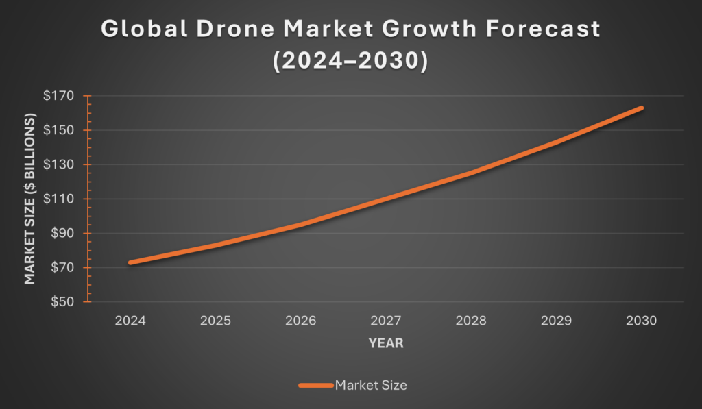
Source: Grand View Research
How InTerra Fits
InTerra addresses this challenge by providing a measurement framework designed specifically for high-accuracy drone mapping. The InTerra system combines three components: SmarTargets®, which act as witness measurements during drone flights; the Datum™ Local Base Station, which provides a nearby GNSS reference; and Locator™ software, which performs transparent post-processing of the collected observations. Together, these components establish a traceable link between field measurements and coordinate systems, enabling drone mapping workflows that produce repeatable, accurate, and defensible geospatial results.
By integrating witness measurements, local reference data, and standards-based processing, the InTerra system helps surveyors, engineers, and infrastructure professionals generate high-quality spatial data with greater confidence. As drone mapping adoption continues to expand across industries, measurement frameworks like this will play an increasingly important role in ensuring that drone-derived data meets the accuracy and reliability requirements of professional surveying and engineering applications.
Download the Whitepaper
Gladys Mae West, GPS, and the Invisible Infrastructure Behind Every Precise Measurement
Gladys Mae West, GPS, and the Invisible Infrastructure Behind Every Precise Measurement
Most of us take GPS for granted.
We expect our phones to know exactly where we are.
We expect drones to map land down to centimeters.
We expect coordinates to just work.
What we rarely see are the people—and decades of quiet, rigorous science—behind that certainty.
One of those people was Gladys West.
A mathematician whose work laid the foundation for GPS as we know it today, Gladys West spent her career solving one of the hardest problems in geospatial science: accurately modeling the shape of the Earth.
Without her work, GPS wouldn’t exist in its modern form.
Who Gladys West Was
Gladys West was a mathematician at the U.S. Naval Surface Warfare Center beginning in the 1950s—a time when both computers and opportunities for women, especially Black women, were scarce.
Her work focused on geodesy: understanding the Earth’s shape, gravitational field, and how to represent it mathematically.
Using early computers and satellite data, she helped develop increasingly precise models of the Earth—models that later became essential to satellite-based positioning systems.
GPS didn’t suddenly “appear” in the 1990s.
It was built on decades of math, patience, and precision.
Gladys West was one of the people who made that possible.
Why GPS Accuracy Is Harder Than It Looks
Knowing where something is sounds simple—until you try to do it precisely.
The Earth isn’t a perfect sphere.
Satellite signals aren’t perfect.
Time itself has to be corrected for relativity.
Every accurate coordinate depends on:
- Reliable satellite data
- Precise Earth models
- Careful correction of tiny errors that compound over distance
When you’re off by a meter, it might not matter.
When you’re off by a centimeter, it matters a lot.
Surveying, construction, engineering, and mapping all depend on this invisible infrastructure of accuracy.
The Line from Gladys West to Modern Surveying
At InTerra, we think about this lineage, how did we get to where we are today?
Our work—building systems for survey-grade drone mapping—depends entirely on the foundation laid by pioneers like Gladys West.
Every Ground Control Point.
Every GNSS correction.
Every sub-centimeter result.
All of it traces back to the same fundamental question she worked on:
How do we know exactly where we are on Earth?
We don’t see GPS as “just a feature.”
We see it as scientific inheritance.
Why This Matters Now
As drones, automation, and AI reshape how we measure the world, precision is becoming more—not less—important.
The more advanced our tools become, the more they rely on:
- Trustworthy reference systems
- Verifiable accuracy
- Proven geospatial science
That’s why honoring people like Gladys West matters.
Not just because she deserves recognition—but because accuracy has a history.
Gladys West didn’t build GPS for recognition.
She built it because the math mattered.
Dr. Gladys West passed away on January 17, 2026, at the age of 95. She is one of the hidden figures of our technical world, whose contributions shaped systems used every day. While her name may not be widely known outside GPS circles, her work continues to quietly support nearly every precise measurement made today.
Today, every time a survey closes accurately, a drone map aligns perfectly, or a coordinate holds up in the real world, her work is still there—quietly doing its job.
We’re grateful for that legacy.
And we’re committed to carrying it forward with the same respect for precision.